Proud To Announce Google Maps Alternative
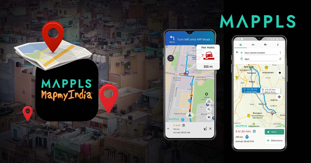
When it comes to viewing maps and getting driving directions, there is no bigger name than Google. But Google Maps Alternative has come from India, which will soon end this monopoly of Google. This app’s name is Mappls, and MapMyIndia is the company that created it.
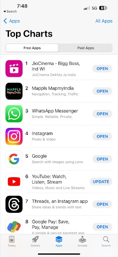
This app is currently serving giant companies and government authorities such as Amazon Alexa, Apple, HDFC Bank, the Ministry of Finance, etc. Recently, it has achieved the number 2 position on the Apple Play Store. This maps for android also ranks at #1 in maps and navigational category.
 MapmyIndia Company Profile and Overview
Google Maps dominated the web-mapping market by acquiring its main competitor, Waze, in 2013, capturing over 70% of the market share. Now let’s talk about MapMyIndia. Firstly, let’s check out what this company does.
Why Are We Saying That It Is A Google Maps Alternative?
No doubt mappls is currently in the race of best maps online. MapmyIndia provides navigation, tracking, IoT, analytics, and web mapping services for desktop and mobile devices. It also offers advanced GPS devices, in-dash infotainment, and plug-and-play on-board diagnostic car trackers.
MapmyIndia offers advanced features like speed limit indicators, pothole indicators, 360 degree view and 3D junction views, setting it apart from Google Maps. These features aim to prevent accidents and improve road safety. You can get it from the apple play store shop or the Google Play store. So let’s talk about the founders of the company.
Founder of MapMyIndia
 In this photo, you can see Rashmi Verma, Rakesh Verma, and Rohan Verma from left to right.
Rakesh and Rashmi Verma set up MapmyIndia in 1995. In New Delhi, India, the two of them set up a business called CE Info Systems.
They said that by 2020, geolocation information would be part of 80% of all data. Rashmi Verma led MapmyIndia’s ground-breaking effort to lay the foundation, framework, and design for a digital mapping model in India that can grow and be used by many people.
Before MapMyIndia, she had a long career in the United States. During that time, she worked at IBM. On July 26, 2007, Rakesh Verma became a full-time Director at MapmyIndia.
Also Read, Know Why VPS Will Be The Future And GPS Will Soon Become History
Features and Functionality That Mappls Provides
1. Mappls Pin
Mappls Pin aims to create a simple, standardized, and precise pan-India digital address system to address the diverse dialects, languages, and cultural differences in India. If I had to share my location live on map, I would definitely use Mappls Pin.
2. Smooth and Reliable Navigation
With Mappls, you can look at high-tech, real-time 2D and 3D maps on the web. It has both visual and audio traffic, danger, and road situation alerts, as well as step-by-step instructions. Users can quickly see where they are in relation to their location by looking at a trip overview.
3. Digital Address and Location Identity System
Mappls ID is a digital number that can be used to identify names and places in Mappls. This tool gives names and areas their own unique identifiers, which makes it much easier to share and find specific places.
4. IoT Tracking
With Mappls Gadgets, you can check on the safety of your car and your family in real time. With the IoT tracking feature, users can check on their smart gadgets like Drivemate and Safemate at any time.
5. Junction View
Junction and 360 degree view is a brand-new feature of Mappls which make it a Google Maps Alternative. This feature shows a photo-realistic 3D picture of upcoming junctions, crossroads, and flyovers so that users can safely drive through complex road networks.
6. Comprehensive Tech Stack
Mappls offers a complete set of APIs and software development kits (SDKs) for mapping and location services. With tools like these, coders can use Mappls’s many features, functions, and skills in their own work.
7. Offline Viewing
It feels bad when you can’t use maps on places where you don’t have any internet. Mappls provides offline viewing which makes it the best maps online. This feature allows users to download maps for offline use, which is useful when traveling to areas with limited or no internet connectivity.
Comparison with Google Maps
Now let’s focus on mappls vs google maps. Google Maps is known to offer accurate navigation, real-time traffic updates, alternative routes, and estimated arrival times for efficient destination-finding and travel planning. Whereas MapmyIndia offers features like speed limit indicators, pothole indicators, and a 3D junction view.
When talking about mappls vs google maps, you should know that google is still trying for 360 degree street view. Even though the Center banned Google Maps’ 360-degree panoramic Street View six years ago because of security issues, the feature was brought back on July 27, 2022.
As an option to Google Street View, MapmyIndia offers the Mappls RealView feature, 3D interactive maps, and the 3D metaverse maps service. The CEO of MapmyIndia, Rohan Verma, called it a “fully indigenous alternative to foreign map apps” because it has better features and gives users more value. In the Mappls RealView maps collection, you can find hundreds of thousands of kilometers and more than 40 million geo-tagged 360-degree images and videos.
Gadgets Provided By MapMyIndia
1. Advanced GPS Vehicle Trackers
Advanced GPS Vehicle Trackers provide real-time vehicle and asset tracking with geofencing alerts, overspeeding alarms, daily distance traveled, trip replay, ignition on/off alerts, and driving behavior. Available as deep-installed or plug-and-play devices, starting at ₹4490.
2. Mappls Dash Cameras
Mappls Dash Cameras, also known as Mappls CarEye, are a personalized safety, tracking, telematics, and surveillance system. They provide real-time video visibility, live streaming of front and cabin views, and analyze driver behavior, detecting acceleration, braking, cornering, and overspeeding. Priced at ₹23,990.
3. Mappls In-Dash Navitainment Systems
Mappls introduces ICENAV Systems, offering Android-based audio, video, offline, and online navigation in its Navitainment Systems. Available in ICENAV 7464 and 7216 variants, with 64GB of internal memory and built-in Play Store and WiFi Hotspot.
4. Mappls Smart Helmet Kits (Navisor and Navaudio)
The Mappls Smart Helmet Kit combines Navisor and Navaudio, transforming helmets into smart devices with hands-free visual LED cues and audio navigation. Navisor uses Augmented Reality for visual navigation and features crash detection, a SOS sensor, auto-brightness, and a 12-hour battery life. The combo is priced at ₹ 5,490.
FAQs
 What is the Indian competitor to Google Maps?
MapmyIndia Move, an Indian competitor of Google Maps, is a popular alternative to the popular platform.
How is MapMyIndia different from Google Maps?
MapmyIndia offers unique features like speed limit indicators, pothole indicators, and a 3D junction view, setting it apart from Google Maps.
Does Apple use MapMyIndia?
Apple uses MapmyIndia for India’s map data.
What is the rating of MapMyIndia?
Mappls had a 4.2 star rating with a total of 20.2k reviews and 1M+ Downloads on the Google Play Store. On the Apple App Store, this app had a 3.9-star rating with 944 total reviews.